Why Accurate Land Surveys Are Essential in Legal Disputes
The Role of Boundary Surveys in Resolving Conflicts
Boundary surveys are a vital component in real estate law, especially during boundary disputes. These surveys provide legal clarity about where one property ends and another begins. When neighbors disagree about property lines—often after years of informal use or unrecorded modifications—a certified boundary survey becomes the definitive source of truth.
Attorneys representing landowners need reliable, court-admissible data to defend or assert their client’s property rights. Selkirk-Cabinet provides highly detailed and professional surveys to support these legal claims.
Surveying Mistakes That Cause Lawsuits
Land disputes often begin with one of the following issues:
-
Fence encroachments
-
Misplaced buildings or sheds
-
Incomplete subdivision plats
-
Historic deed inconsistencies
If the original survey was incomplete or used outdated methods, it can trigger years of legal conflict. Selkirk-Cabinet mitigates this risk using advanced equipment and techniques that meet today’s legal standards.
Legal Support for Attorneys and Landowners
Selkirk-Cabinet has worked alongside numerous attorneys in Northern Idaho and Northeast Washington. We don’t just deliver fieldwork—we provide annotated maps, sworn affidavits, and expert witness services to support your case in court. Our team understands the level of precision and clarity that litigation requires.
Selkirk-Cabinet’s Surveying Services Explained
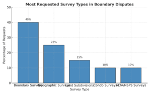
Boundary Surveys and Complex Boundary Disputes
Whether you’re resolving a fence dispute or dealing with a century-old deed, our boundary surveys deliver exact coordinates based on current and historic legal records. We combine GPS data, field measurements, and document research to produce an authoritative boundary report.
Here’s what’s included:
-
Detailed survey map
-
Monumentation of corners
-
Legal description of property boundaries
-
Supporting documentation for court or title companies
We specialize in complicated boundary disputes, particularly those involving unclear title chains or overlapping claims—often found in rural properties around Sandpoint, Bonners Ferry, and Priest River.
Land Subdivisions and Platting for Growth
If your client is subdividing land for sale, inheritance, or development, we offer full land subdivision services, including:
-
Preliminary plat design
-
Final subdivision surveys
-
Legal descriptions
-
Filing and coordination with county planning offices
Subdivision surveys are not just about drawing lines—they’re about planning for long-term value, compliance, and land use integrity.
Condo Surveys and Topographic Mapping
Condo surveys (also called “as-built surveys”) are essential for new condominium developments and conversions. They map out the vertical and horizontal extents of each unit and common space.
We also provide topographic surveys, ideal for:
-
Pre-construction site planning
-
Drainage and grading studies
-
Engineering and architectural design
Topographic maps include elevation contours, vegetation, structures, and drainage features, giving professionals the full picture before breaking ground.
Working With Attorneys on Boundary Disputes
Expert Testimony & Legal Documentation
At Selkirk-Cabinet, we don’t just hand over a map—we stand behind our work in court. Our team is trained to present findings clearly in legal settings. Whether it’s a deposition, mediation, or trial, we provide:
-
Sworn affidavits
-
Written expert opinions
-
Visual exhibits for court
-
On-site presentations if needed
Our surveys meet standards required for admissibility in Idaho and Washington courts.

Real-Life Survey Dispute Case Study in Sandpoint, ID
Recently, a Sandpoint attorney contacted us about a dispute involving a 5-acre residential parcel with a legacy fence line dating back 40 years. After comparing GPS measurements, archived plat maps, and original deed descriptions, our boundary survey revealed a 12-foot encroachment by the neighbor’s garage.
We presented our findings with annotated aerial imagery and live field data. The matter was resolved without going to trial—thanks to irrefutable survey evidence.
How We Help Build a Strong Case
Here’s what attorneys can expect when partnering with Selkirk-Cabinet:
-
Timely communication and status updates
-
Thorough title review for inconsistencies
-
Cross-checking adjacent properties
-
Custom visuals for judge/jury comprehension
We act as a behind-the-scenes expert, helping attorneys navigate the complex intersection of surveying, law, and property rights.
What to Expect When Hiring Selkirk-Cabinet
Survey Process and Timeline
Each project starts with a free consultation. Once we understand your needs, we’ll prepare a proposal outlining:
-
Scope of services
-
Estimated timeline
-
Deliverables and legal documentation
Typical project timeline:
-
Document review (deeds, plats, prior surveys) – 1–2 days
-
Fieldwork and measurement – 1–3 days
-
Analysis and drafting – 2–5 days
-
Final report and deliverables – 1 day
Most boundary surveys are completed within 1–2 weeks.
Local Expertise in Northern Idaho and NE Washington
We’ve served clients across:
-
Sandpoint, ID
-
Bonners Ferry, ID
-
Priest Lake, ID
-
Newport, WA
-
Colville, WA
-
Metaline Falls, WA
Our team understands the quirks of mountain terrain, legacy land grants, and county-specific regulations. That local insight saves time and avoids red tape.
Tools, Tech, and Accuracy Standards
We use:
-
Trimble GNSS GPS systems
-
Robotic total stations
-
AutoCAD Civil 3D for drafting
-
LIDAR-assisted mapping when needed
Our work complies with Idaho’s Board of Professional Engineers and Land Surveyors and Washington State standards.
FAQs About Boundary Disputes and Surveying
What Triggers a Boundary Dispute?
Boundary disputes often arise from:
-
Disagreements about fence placement
-
New construction near property lines
-
Conflicting deed descriptions
-
Neighbor complaints or permit rejections
If there’s doubt about a property’s legal limits, a survey is the fastest route to clarity.
How Long Does a Boundary Survey Take?
Most projects take 7–10 business days, depending on complexity, weather, and availability of existing records. Larger rural properties may take slightly longer.
Who Pays for the Survey in a Dispute?
In many cases, the landowner initiating the survey pays. However, in legal disputes, costs may be shared or awarded by the court as part of a settlement. We offer clear invoices and itemized billing for legal documentation.
Key Takeaways
-
Selkirk-Cabinet specializes in boundary surveys for complicated disputes in Northern Idaho and Northeast Washington.
-
We support attorneys and landowners with precise, court-ready survey data and expert witness services.
-
Services include land subdivisions, topographic surveys, and condo surveys.
-
We combine legal expertise with technical precision, helping resolve disputes quickly and accurately.
Ready to Resolve a Land Dispute?
Contact Selkirk-Cabinet today to schedule a consultation or request a boundary survey. Whether you’re a property owner or legal professional, our team will deliver the accurate results your case depends on.
📞 Call now: [Insert Phone Number]
📧 Email us: [Insert Email]
🌐 Visit: https://selcabsurvey.com/home


